
Fitz Roy: Choose a Viewpoint and Plan for Weather
Choose a Fitz Roy viewpoint that fits your day. Compare the named lookout, Laguna Capri and Laguna de los Tres with source-defined starts and returns.
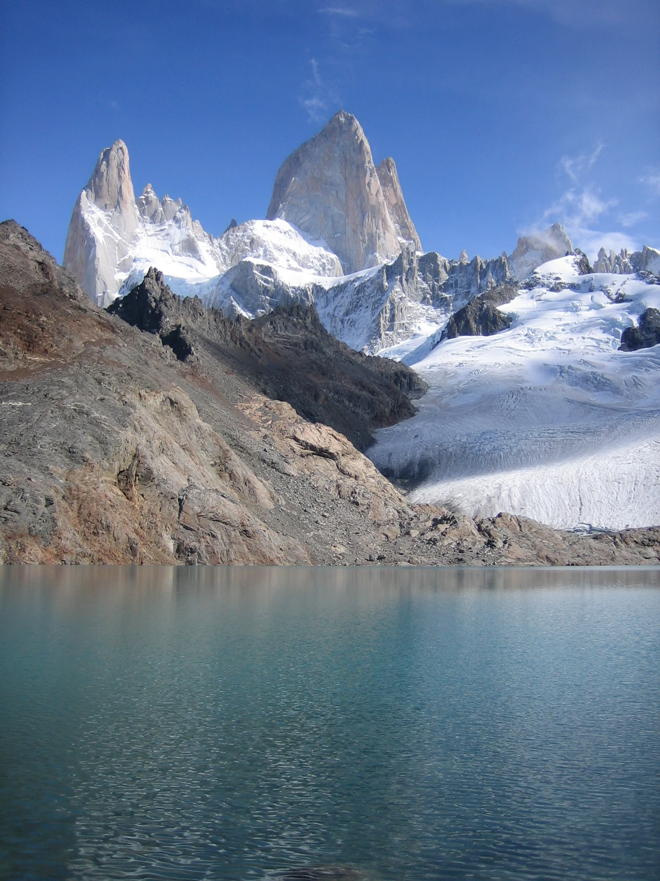
Fitz Roy 1.jpg by Prissantenbär, Public domain. Resized and converted to WebP.


Fitz Roy is the mountain, while the visitor decision is which viewpoint walk to choose. Laguna Capri, the named Fitz Roy viewpoint and Laguna de los Tres give different walking commitments. Choose the route that fits your available day and current conditions. Avoid treating seeing the mountain as one fixed hike.
Choose a shorter Fitz Roy-area viewpoint or Laguna Capri for a smaller trail commitment. Choose Laguna de los Tres when the longer ascent and complete return fit you. APN maps the routes separately and lists their one-way references. Visibility depends on weather. A place on a map or a room with a mountain-view label cannot guarantee that the peak will be clear.
Fitz Roy and the hiking area
The mountain sits within the northern Los Glaciares landscape associated with El Chalten. APN's northern brochure names the mountain and maps the visitor walking routes around it. This guide concerns those ordinary viewpoint outings, not a summit climb.
The El Chalten planning guide helps put the town stay and walking choices together. A day hike begins from the place you reach. A general area package can visit the area without following the same trail you have in mind.
Ask for the exact route when a seller lists a Fitz Roy day. It may mean a shorter viewpoint, a Capri walk or a longer lake outing. Read the starting point and turnaround before comparing distance or effort.
Where visitors can see Fitz Roy
APN's trail material labels a Fitz Roy viewpoint and the two lake places. Those named routes give a useful choice of purpose. Weather still decides what is visible from a place when you arrive.
| Viewpoint choice | Route purpose | Trade-off |
|---|---|---|
| Named Fitz Roy viewpoint | A park-labelled mountain viewpoint | The complete approach and return still need time |
| Laguna Capri | A lake-focused outing in the same wider walking area | A lake visit is not the final Laguna de los Tres ascent |
| Laguna de los Tres | The longer lake-and-mountain route | More distance and a steep-trail warning |
| A town or lodging view | A view from your real base when available | Room position and cloud can differ from a photo |
Scroll for more →
A town or room view can be worthwhile without a long walk, but check what is being sold. A lodging photo may show a view from a common area or one room. Ask about the selected room rather than applying that image to the whole property.
Do not choose the longest trail solely because it has the most famous image. A shorter outing can answer the purpose of seeing the mountain while leaving more of the day for the return. It should still be assessed as a mountain walk under the current park rule.
Fitz Roy viewpoint hike choices
The park brochure lists the named Fitz Roy viewpoint and Laguna Capri at four kilometres one way on their route references. It lists Laguna de los Tres at ten kilometres one way, with a larger vertical difference. These figures were checked October 2026 in that brochure.
Keep the endpoints explicit. The brochure also has a separate visitor-centre approach to the start. A distance measured from a hotel or another northern arrival can therefore differ from a trail-table reference without describing exactly the same day.
The Laguna Capri guide explains the shorter lake choice. Use the Laguna de los Tres guide to judge the longer route and its steep section. Neither page treats a printed walking duration as a guarantee of your pace.
If you want both a lake and another viewpoint, use the linking paths on the official map. Do not add two separate out-and-back totals. Shared approaches and different return branches affect the real combination.
Access from El Chalten
Read the route references in your preferred units
Four kilometres is about 2.5 miles, and ten kilometres is about 6.2 miles. Those are rounded unit conversions of the brochure's one-way distances. They retain the same starting-point limits. So they should not be read as a complete hotel-to-hotel day.
| Park distance reference | Rounded miles | Add separately |
|---|---|---|
| Four kilometres one way | About 2.5 miles | Return and any town approach |
| Ten kilometres one way | About 6.2 miles | Return and any different access route |
Scroll for more →
Changing units does not change the route or effort. Keep the real endpoints beside either figure. A longer trail with the same mountain as its purpose still asks for a different day.
Reach the town base with enough useful time for the chosen walk. Arrival and departure days can leave less time than a brochure's headline suggests. A late bus arrival is not automatically a right start for a long mountain outing.
Read the real route start on a guided product. A vehicle can take a group to another northern access. A self-guided day may start from town. That difference affects the walking total and how you get back.
If a transfer is involved, keep the final pickup in the day plan. Reaching the viewpoint is not the end of the route. A guide can arrange the service it sells. But a transport-only product does not add trail guidance by itself.
Choose a lodging location after choosing the walking pattern. Being in the wider Fitz Roy area does not prove easy walking access to every town trail. Ask the property how you reach your real start and return.
Weather and visibility limits
APN warns that town conditions can differ from the mountains. Check the current advice for the chosen route. A clear town morning cannot prove a safe or clear upper trail for the whole day.
Cloud can hide the mountain from any planned viewpoint. A supplier or Commons photo records one moment. Choose the outing for its route and setting, with the view as a condition-dependent part of it.
Keep a shorter allowed choice in mind when that fits the day. Changing from a long outing to a nearer viewpoint should still involve a route decision and current access check. It should not become an improvised shortcut or an assumption that every branch is equally right.
If the view is hidden when you reach the chosen place, decide how long to pause from the return. Waiting can be pleasant when the weather and time allow. It cannot continue indefinitely without changing the walking day.
Building a realistic viewpoint day
Start with one main purpose: the named lookout, the lake or the longer lake route. Put the town approach beside it. Add the return before booking any later transport or meal that needs a fixed time.
Use the park's route figure as a comparison reference. Read whether it is one-way and where it begins. Then compare it with your party's pace and the current rule. A more demanding area should not be selected merely because it appears nearby on the map.
For a guided outing, ask which area is planned and which shorter alternative the guide may use. Read whether that alternative is a normal condition-dependent route choice or a different purchased service. Clear terms help avoid treating any mountain view as equivalent to the product you expected.
For self-guided walking, agree on the planned return before leaving town. Keep the route within the allowed network. If the conditions or pace make the original purpose unsuitable, an allowed turnaround is a complete decision rather than a failed attempt to reproduce a photo.
Questions before choosing a view
Is Fitz Roy the name of one hiking trail?
It is the mountain name, and several visitor routes in its area offer different viewpoints. Ask which area a tour means by a Fitz Roy hike. The named lookout, Laguna Capri and Laguna de los Tres have different purposes and walking commitments. The real start and return belong in that comparison too.
Do I have to reach Laguna de los Tres to see the mountain?
No single viewpoint is the only choice. APN labels a separate Fitz Roy viewpoint and Laguna Capri within the wider walking area. Choose a route that fits your day and present conditions. Seeing the mountain still depends on visibility, so neither a shorter nor longer walk can promise the view.
Why do published hike distances differ?
Compare the starting point, area and return. A trail-table figure may begin at the mountain trail, while another total starts from a hotel or a different northern access. A combination can also use another branch. Keep those endpoints visible before treating two numbers as descriptions of the same outing.
Can a guided tour guarantee a clear Fitz Roy view?
No. A guide can lead the allowed outing it sells and handle the agreed service, but cloud still affects visibility. Read how the route can change for conditions and what is included. A photo or a area name does not prove that the mountain will be clear during your own visit.
Sources and facts last checked
Checked October 2026: APN's 2024 northern trail brochure and current Los Glaciares visitor pages. The listed trail references are kept separate from the real town approach and weather conditions.
Verdict on Fitz Roy viewpoints
Choose the Fitz Roy viewpoint route by the day you can walk. Keep the area, start and return distinct. A shorter allowed outing can be the right choice when it fits your purpose and conditions better than the longer lake ascent.