
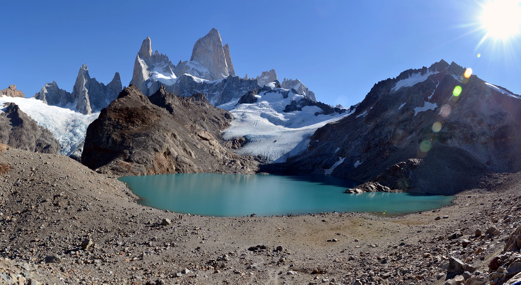
Laguna de Los Tres: Trail Starts, Effort and the Final Climb
Plan Laguna de los Tres as a full ascent and return. Read APN's distance and height reference, the steep-trail warning, access checks and shorter choices.
Laguna de Los Tres Panorama.jpg by Rodrigo Menezes (Ironman br), CC BY-SA 4.0. Resized and converted to WebP.

Laguna de los Tres is a full mountain-walking day in the Fitz Roy area. Plan the ascent and return from your real starting point. The lake viewpoint is different from the shorter Laguna Capri outing. Its steeper approach deserves its own weather and turnaround decision.
Choose Laguna de los Tres when the complete route fits your party and the current park conditions. APN's trail brochure lists ten kilometres one way and a 750-metre height difference for its route reference. Include the return and any town approach. Keep the shorter Capri option as a separate choice, rather than extending a short walk without a new plan.
Route and trailhead choices
APN's northern trail brochure maps the town approach, Poincenot and the branch to the lake. It also maps links toward Rio Electrico and other northern places. Those lines are route references, not a promise that every approach is currently open.
Use the El Chalten guide to choose the town base and real arrival. A room somewhere in the wider area does not prove that you start at the town trailhead. Ask a guide or transfer provider which start and finish it uses.
The start point affects distance and logistics. A town out-and-back and a trip with a different northern drop-off need separate totals and return plans. We do not apply one published distance to every version described as the Fitz Roy hike.
Laguna de los Tres distance and estimated effort
| Brochure reference | What APN lists | Planning limit |
|---|---|---|
| Mountain-trail distance | Ten kilometres one way | Add the return and any town approach |
| Listed height difference | 750 metres | Not a detailed cumulative ascent profile |
| Duration | Five hours one way | A route estimate rather than a guaranteed pace |
| Route warning | Very steep; danger in wind and rain | Current park advice governs whether to continue |
Scroll for more →
The fields were checked October 2026 in the park's 2024 English brochure. A matching out-and-back gives about twenty kilometres on that mountain-trail reference. This is arithmetic from the printed one-way distance, not a measured GPS track.
The brochure separately lists the visitor-centre approach to the trail start. Keep that part of the town journey out of the mountain-trail total until you know where you begin. A hotel close to another street may have a different approach again.
Other published route plans can use different starting points and estimates. Compare the endpoints before deciding that two totals describe the same day. Choose a conservative plan for your pace and current conditions. Avoid forcing the walk into a supplier's shortest example.
Walking stages and the ascent
Read the route in parts: reach the start, follow the approach through the Fitz Roy network, take the lake branch and return to the real finish. The view at the lake is one point in that complete day, not its end.
The official map names Poincenot on the approach to Laguna de los Tres. Use it as a reference node while reading the route, with the park signs and rule on the day. A campsite symbol is not a reason to assume you can add an overnight stay without checking the allowed plan.
The lake branch is the larger commitment that separates this outing from a shorter Capri day. APN gives a steep-trail warning. Decide whether the conditions and time fit before taking that part. Avoid relying on having already walked most of the approach.
At the lake, keep the return in mind. A long pause while waiting for a clear view can use time needed to descend. Choose the stop from conditions and the complete plan, not from a promise that the mountain will become visible shortly.
Turnaround and weather decisions
Check mountain-trail advice with the park. Its brochure warns that town and mountain conditions differ. A calm street in El Chalten does not prove that the steeper route is right higher up.
Choose a turnaround that leaves room for the descent and return approach. If the day is slower than expected, a shorter allowed area can be the right outcome. Reaching the named lake should not override the park's warning or the time needed to get back.
If travelling with a guide, ask how it handles different paces and a changed route. A guide leading the whole group may not be able to take one person elsewhere without another plan. Settle that question before buying if it affects the trip you want.
If walking independently under the allowed plan, make the route purpose clear within the party. Do not let a junction create an unplanned extension. Everyone should understand the planned finish and the point at which the group would turn back.
Current access and park rules
Use APN's current visitor pages for entry and present rules. The brochure is valuable for orientation and listed route references, but it is not a live condition feed.
APN's outing details includes registration rules for remote-area trekking and seasonal rules. Ask which need applies to the exact outing and date. A general tourism page describing a popular trail does not override a park limit.
Keep to the marked public route and follow the local advice. Do not use an informal shortcut to recover time or get closer to the lake. A route seen in a photo is not proof that visitors may walk there.
The protected area's entry and a guided service are distinct tasks. Ask whether a package includes entry, which trail it uses and where the guide joins. A bundled title alone does not settle all three.
Alternatives and onward planning
The Laguna Capri guide compares the shorter lake-focused outing. It can be a deliberate choice for a day with less time or a different walking purpose. It is still a mountain trail, so judge its own access and return. Avoid treating it as an automatic easy substitute.
Use Fitz Roy viewpoints when the main purpose is seeing the mountain rather than reaching this chosen lake. A different viewpoint can answer that purpose under right conditions without reproducing the same route.
Choose the day walk deliberately
Read the El Chalten hike comparison before committing your available day to the longest option.
A full-day planning reference
Before departure: settle the real start, current access and return. Put the park's listed one-way figures beside the complete journey. Keep the planned lake and any shorter alternative distinct.
During the approach: judge the real pace against the remaining route. Read the local signs and rule. Do not treat a long approach already completed as a reason to continue into unsuitable conditions.
Before the steeper part: review the park warning and time left. A guide's rule or ranger limit can change the plan. If the lake no longer fits, choose the allowed return rather than creating another route.
At the viewpoint: decide the pause from the conditions and descent. Clear mountain visibility is welcome but uncertain. The return still belongs to the day's task, including any road pickup or lodging journey afterwards.
Plan food and the return at the same time
Keep enough food and water for the complete outing you chose, including a slower descent. Do not use the final ascent as the moment to discover that the main meal is still in town. A short rest before the steep part can also be a useful point to reassess the party's pace.
When comparing guided versions, ask where the walk begins and whether the stated total includes the way back. Different trail starts can change both the road task and the distance on foot. A guide may help manage the day but cannot make a late start fit an unsuitable return. Keep the descent inside the allowed plan and your transport window.
Questions before the lake hike
How far is Laguna de los Tres from the trail start?
APN's English northern brochure lists ten kilometres one way for its trail reference. A matching out-and-back gives about twenty kilometres before extra town walking. Use the same start and finish when comparing another total. A different northern approach or a hotel journey needs its own route and transport plan.
Is Laguna de los Tres the same as Laguna Capri?
No. They are separate lakes and walking purposes in the Fitz Roy area. Laguna de los Tres has the longer commitment and a steep-route warning in the park brochure. Choose the whole day before departure. Continuing from a shorter outing should need a fresh decision about time and conditions.
Does the brochure's time estimate guarantee a return time?
No. It is a listed route reference, with one-way duration clearly marked. Add the descent and any town approach, and allow for your pace and stops. Conditions can differ from the estimate. Do not treat a printed time as a promise that you can make any chosen afternoon pickup.
Should I wait at the lake until Fitz Roy appears?
Choose the pause from the weather and the return time. Cloud can remain, and a photo cannot promise your view. If waiting would make the descent or return unworkable, leave by the allowed route. The mountain view is one purpose of the walk, while completing the day is another useful task.
Sources and facts last checked
Checked October 2026: APN's 2024 northern trail brochure, route table and current visitor pages. The arithmetic return distance is labelled above. Listed vertical difference is not presented as a surveyed cumulative elevation profile or a guaranteed walking effort.
Verdict on Laguna de los Tres
Choose Laguna de los Tres for a full route that fits the present conditions and your available day. Keep the start point, steep ascent and complete return in the plan. A shorter allowed choice is preferable when those parts no longer work together.